The proximity toolset in ArcMAP contains multiple tools to calculate proximity. According to the ArcMAP documentation these tools can be used to: “determine the proximity of features within one or more feature classes or between two feature classes”.
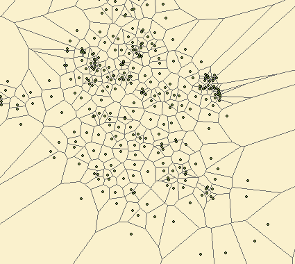
The “Create Thiessen Polygons” is a proximity tool that calculates polygons from a point feature layer. Each polygon contains one feature point, and any location within a polygon is at anytime closer to its allocated point than to any other point input feature. The size of each polygon can vary greatly based on the dispersion of the point input features.
The Delaunay triangulation method is used to calculate the polygons which works best in a projected coordinate system, and may therefore yield unexpected results in a geographic coordinate system.
Sources:
Create Thiessen Polygons
Proximity Tool Set